Gorontalo is located in the North Arm of Sulawesi which is a volcanic arc formed by a double subduction, namely the North Sulawesi Subduction in the north and the East Sangihe Subduction in the east and south. The subduction produces magmatism and volcanism activities that produce widespread plutonic and volcanic rocks.
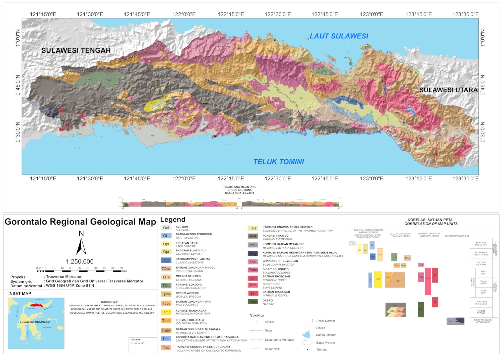
Figure 1. Geological map of Gorontalo (Bachri et.al, 1993; Apandi and Bachri, 1997).
The oldest rock unit is the Tinombo Formation (Eocene – Early Miocene). The Tinombo Formation was formed at the same time as the gabbro intrusion, which was overlain by the Bilungala Volcanic, the Dolokapa Formation, and the Randangan Formation (Middle Miocene – Early Pliocene). At the same time, Diorite Bone was formed which was supposed to be comagmatic to the Bilungala Volcanic.
Then formed Pani Volcanic, Wobudu Breccia, and Motomboto Volcanic in the Middle Pliocene. Simultaneously, the Boliohuto Diorite was formed which was supposed to be comagmatic to the Pani Volcanic, Wobudu Breccia, and the Motomboto Volcanic.
In the Late Pliocene - Early Pleistocene the Lokodidi Formation was deposited. At the same time, the Pinogu Volcanic and the Bumbulan Granodiorite were formed. In the Plio-Plistocene, Reef Limestone and Lake Deposits were formed. The uplift is supossed to have occurred since the Early Pleistocene.
The biggest lateral fault is the Gorontalo Fault The largest horizontal fault is the Gorontalo Fault, which based on analysis of the accompanying joints suggesting right-handed movement. There are several fault zones with an angle of 30⁰, especially in the Bilungala Volcanic Rock. Compression tectonic periods that occur more than once produce folds.
References:
Apandi, T. and Bachri, S. (1997). Peta Geologi Lembar Kotamobagu, Sulawesi. Bandung: Pusat Penelitian dan Pengembangan Geologi.
Bachri, S. (2006). Stratigrafi lajur volkano-plutonik daerah gorontalo, sulawesi. Jurnal Geologi Dan Sumberdaya Mineral, 16(2), 94-106.
Bachri, S., Sukido, and Ratman, N. (1993). Peta Geologi Lembar Tilamuta, Sulawesi. Bandung: Pusat Penelitian dan Pengembangan Geologi.
Molnar, P., & Dayem, K. E. (2010). Major intracontinental strike-slip faults and contrasts in lithospheric strength. Geosphere, 6(4), 444-467.
Simandjuntak, T. O. (1986). Sedimentology and tectonics of the collision complex in the East Arm of Sulawesi Indonesia. University of London, Royal Holloway and Bedford New College (United Kingdom).