1. Physical Characteristic
Gorontalo based on its physiographic conditions is divided into four physiographic zones. The four physiographic zones are the Tilongkabila Boliohuto North Mountain Zone, the Paguyaman-Limboto Interior Plain Zone, the Bone-Tilamuta-Modello Southern Mountain Zone, and the Pohuwato Coastal Plain Zone.
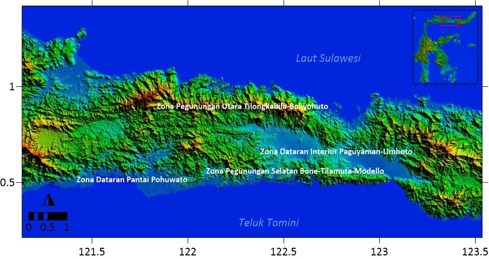
Figure 1. Gorontalo physiographic zone map. The data source for map generation was obtained from the Shuttle Radar Topography Mission (SRTM) imagery obtained from the US National Geospatial-Intelligence Agency (NGA) and NASA (Taslim, Indrianti, & Manyoe, 2019).
The North Mountain Zone of Tilongkabila-Boliohuto generally consists of volcanic rock formations of Miocene – Pliocene age (approximately 23 million to 2 million years ago). Generally, it consists of intermediate to acidic igneous rocks, namely intrusive rocks in the form of diorite, granodiorite, and some granites. Other rocks are sedimentary rocks originating from volcanoes consisting of lava, tuff, breccia, or conglomerate. The association of these rocks leads to the content of valuable metal minerals, especially gold.
The second zone is a basin in the middle of Gorontalo Province, namely the Paguyaman-Limboto Interior Plain. The wide plain that stretches from Lombongo to the east of Gorontalo City, continues to Gorontalo, Lake Limboto, to Paguyaman, and Botulantio to the west, is the separator between the northern and southern mountains. This plain is a basin that is supposed to be controlled by a normal fault structure that can be observed north of Pohuwato in the Dapi-Utilemba Mountains, or north of Taludaa on Mount Ali, Bone.
The Southern Mountain Zone of Bone-Tilamuta-Modello generally consists of volcanic sedimentary rock formations (Eocene – Oligocene) and diorite, granodiorite, and granite (Pliocene) intrusions. Old volcanic rocks generally consist of basalt lava, andesite lava, breccia, sandstone and siltstone, some containing metamorphosed limestone. As in the north, the association of these rocks also leads to gold mineral content which is mined manually by the people, such as in Bone Pantai, Tilamuta, and Mount Pani, Marisa.
The last zone is a relatively limited zone on the Pohuwato Coastal Plain. The plains that stretch from Marisa in the east to Torosiaje and the border with the Province of Central Sulawesi in the west, are coastal alluvial areas that were mostly swamp areas and tidal zones. Until now, in the south, there are still extensive mangrove swamps, which are actually home to Wallacea's endemic bird, the Maleo.
2. Geographic Characteristic
2.1 Geographical Location
Gorontalo Province is one of the provinces in Indonesia. Gorontalo Province is located in the northern part of Sulawesi Island. Astronomically located at coordinates 0° 19′ 00” - 1° 57′ 00” N and 121° 23′ 00” - 125° 14′ 00” E. Gorontalo Province is bordered by Central Sulawesi Province in the west and North Sulawesi Province in the east. While in the north it is directly opposite the Sulawesi Sea and in the south it is bordered by Tomini Bay.
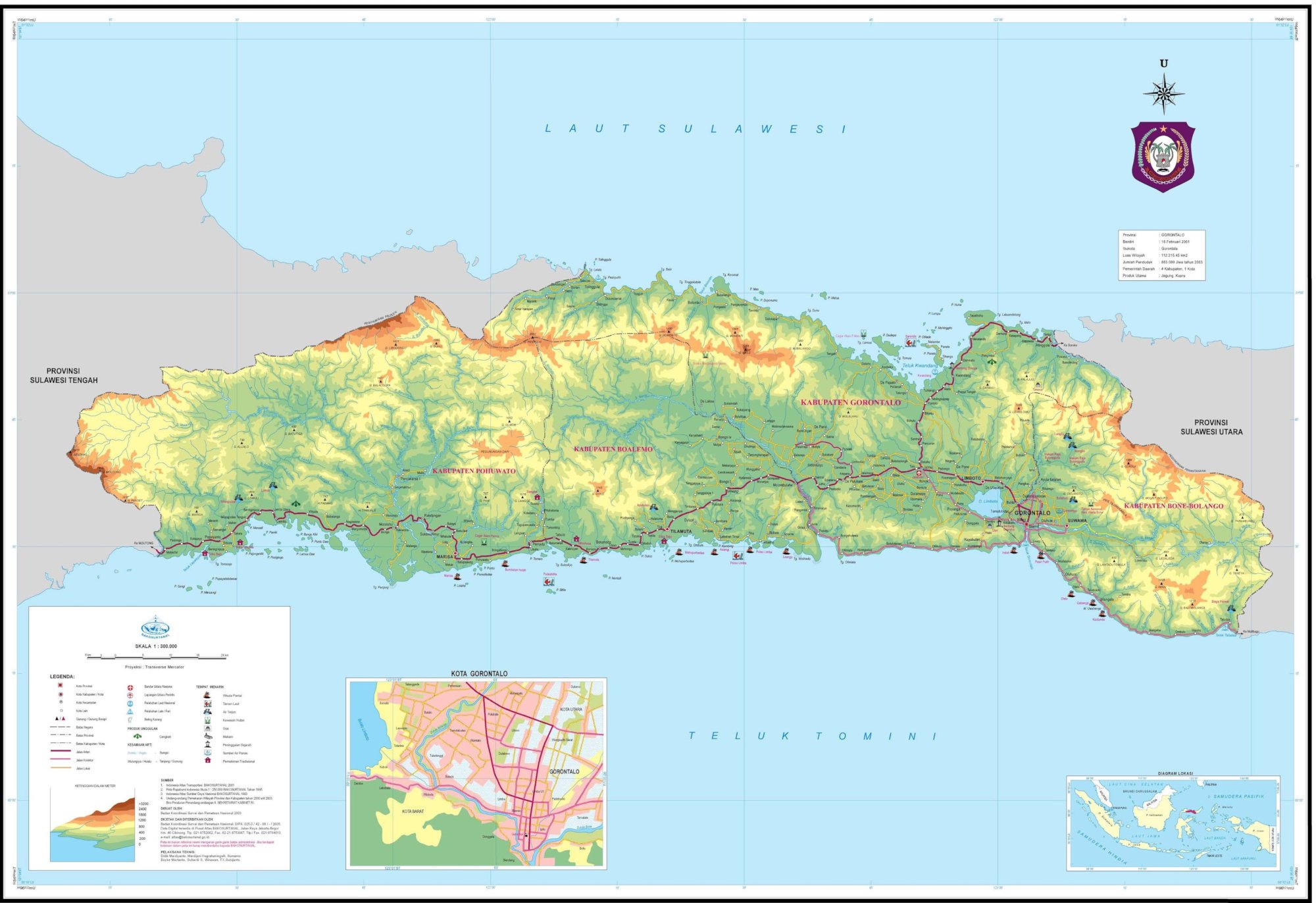
Figure 2. Gorontalo Province map.
Gorontalo Province consists of 5 (five) regencies and 1 (one) city, namely Boalemo Regency, Gorontalo Regency, Pohuwato Regency, Bone Bolango Regency, North Gorontalo Regency, and Gorontalo City. Pohuwato Regency is the largest area in Gorontalo Province with an area of 35.83%, while Gorontalo City has the smallest area in Gorontalo Province at 0.53%.
2.2 Area and Population
The area of this province is 11 257.07 km² with a population of 1,180,948 people, with a population density of 105 people/km². The percentage of population according to religion is Islam (96.93 %), Protestant (1.93%), Catholic (0.68%), Hindu (0.37 %), and Buddhist (0.09 %).
Gorontalo Province is inhabited by various ethnic groups in the form of Pohala'a (Family), including Pohala'a Gorontalo (Hulontalo Family), Pohala'a Suwawa (Suwawa/Tuwawa Family), Pohala'a Limboto (Limutu Family), Pohala'a Bolango (Bulango/Bolango Family) and Pohala'a Atinggola (Atinggola Family). All of Pohala'a are categorized into the Gorontalo or Hulontalo ethnic. (BPS, 2022).
2.3 Climate
The air temperature in a place is determined, among other things, by the height of the place above sea level and its distance from the coast. With the condition of the Gorontalo Province area which is located near the equator, this area has a fairly hot air temperature.
The minimum temperature occurs in February, which is 21.6 ⁰C. While the maximum temperature occurs in October with 35.1 ⁰C. For a year (2021) the average air temperature of Gorontalo Province ranges from 26.6⁰C – 27.3⁰C. Maximum humidity is 100% and minimum humidity is 43%. The average air humidity in 2021 in Gorontalo Province ranges from 81% - 89%.
The highest rainfall is in November 2021, which is 405 mm and the highest number of rainy days occurs in September 2021 as many as 19 days. The average wind speed in 2021 recorded by the Meteorological Station of Gorontalo Province is generally evenly distributed every month, ranging from 1.3 to 1.7 knots (BPS, 2022).
References:
BPS. 2022. Provinsi Gorontalo dalam Angka 2022. Gorontalo: Badan Pusat Statistik Provinsi Gorontalo.
Brahmantyo, B. 2009. Totonu Yio Gorontalo? dalam Ekspedisi Geografi Indonesia 2009 Gorontalo. Jakarta: Bakosurtanal.
Taslim, I., Indrianti, M.A., & Manyoe, I.N. (2020). Kearifan Lokal Ritual Payango hingga Ramalan Panggoba sebagai Mitigasi Bencana Masyarakat Gorontalo dalam Pengetahuan dan Praktik Lokal untuk Pengurangan Risiko Bencana: Konsep dan Aplikasi, Rahman, A., Nurmalahayati., & Nazaruddin, M. (Eds) (UNSYIAH Press, Aceh).